![]()
![]()
![]()
![]()
|
Notes India-Burma Mission |
|||
|
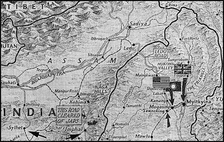
The primary reason the 64th Troop Carrier Group, plus one squadron of the 62nd Troop Carrier Group, went to India was to aid in the relief of about 170,000 British troops who were surrounded by the Japanese in the Imphal Valley (See town of Imphal just below the info box, which reads: "This road cleared of Japs.")
WWII Era Map of CBI Area With a little imagination one can see a relatively flat area around the town of lmphal (in a valley surrounded by mountains). If the Japanese had captured these troops, there was little to stop them from a sweep into Calcutta and other vital points in India. At the town of Sylhet, west of Imphal, where there was a large airfield. It was from here that about three squadrons flew most of their supplies into Imphal. These units were based off the map, about one-and-one-half hours to the southwest of Sylhet. During this operation the Japanese struck Imphal nearly every morning at 8:20 a.m. So, if we left before 8:00 a.m. or arrived after 8:45 a.m., the chance of an encounter was slight. (They had about twenty minutes of fuel that could be used to hang around Imphal.)
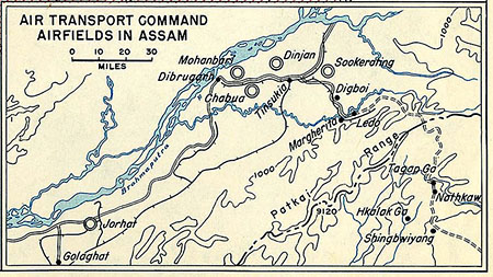
Airfields in Upper Assam, India |
|
||
|
The 18th Squadron was based at Sookerating, in the upper Assam Valley. The Sookerating airfield was built on the Sookerating tea estate in 1942, and the plantation's golf course and horse racing track were used to build the runway. And, a bungalow, or basha, that currently existed on the estate was used for base operations. Some of the aircrews worked out of Dinjan for a while, which was nearby. From this area the Group mostly supported General Stillwell's Army in Burma, and before we left India, he had captured Mitkyina (pronounced mish-en-ah). These two actions effectively ended the Japanese Threat in Northern Burma. However, there was much action later that year to clear Southern Burma using Merrill's Marauders, etc. Note: The Hump is not that section of China near Mitkyina, but it is North of the Assam Valley. |
|
||
|
|
|
||